|
|
|
| Back to Home page | |
 |
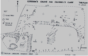
The interesting
humps and bumps in Godson's Grove and Squirrel's Close (names dating
from 1279) were in the first fields to be surveyed by the group.
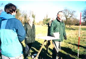
We
asked Steve Kemp of the Archaeological Field Unit of Cambridgeshire
County Council to show us how to use a plane table. The "plane table" consists of:
*A drawing table mounted on
a tripod and clamped in a horizontal
plane. |
| With the addition of measuring tapes and poles this traditional surveying method maps the details of earthworks accurately. A scale is used to plot areas which are then drawn on paper using long and short lines to show the steepness of the slopes. | |
|
|

The pattern of humps in the field is easier to define once it has been plotted on to paper. A ditch runs across the site and the shapes of the raised areas show clearly. Are these where houses once stood?
|
| Links to more details | |
| Documentary evidence | Plane table surveying |
| Place name analysis | Resistivity surveying |
| Aerial photography analysis | Dowsing and pond dipping |
| Geology | Courses and visits |
| Soil sampling | Community links |
| Metal detecting | Acknowledgements |